 The concept of dike comes from the Dutch dijk . The term is used to name the structure that is built with the aim of containing water , preventing its passage. For example: "To prevent flooding, in the 19th century local authorities built a dam" , "Sport fishing is a very popular activity on the dam" , "Neighbors are worried about leaks from the dam" .
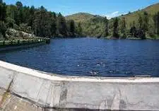
Dams can be built perpendicular or parallel to the watercourse they are intended to contain. These are walls made of concrete, stone, earth or other material that can be erected to prevent flooding in surrounding areas, block a flow of water so that it moves faster, or protect an area from wave action, for example.
When the dam seeks to prevent the advance of water, it is called a retaining dam . Breakwater dikes , on the other hand, superimpose layers of various materials to minimize the energy that comes from the waves, providing protection to a certain place (such as a port ).
That dike that is separated from the coast, generally located parallel to it, is called an exempt dike . These constructions have the same purpose as breakwater dikes. A dry dock , on the other hand, is a port facility that allows ships to be taken out of the water for repairs.
There are dams that are built for the development of hydroelectric plants. That is the case of the Florentino Ameghino Dam , which is located in the Argentine province of Chubut . This dam that contains the waters of the Chubut River allows for the generation of electrical energy and provides protection to different towns.
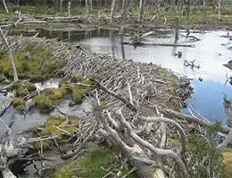
A natural dam , finally, is formed by the drag and accumulation of materials generated by a river, progressively raising the bank . Other names for the river bank are alluvial embankment , levée (a term that comes from French) and bank.
This type of dam is formed at the edge of the river during times when the flow increases. It is very common in plains rivers, whose channels are rambling and with a slight slope.
 It is important to note that one of the causes of the bank rising is that the waters lose speed next to it; This happens because in floods, the peak speed of the water is greater in the center of the river, and this cuts the meanders (the curves that describe the course of the river) on its convex side, the opposite of what happens in the low waters (there, the centrifugal force moves the current towards the concave portion).
Thanks to this phenomenon we can understand the effects that the great Turia flood in Valencia had in 1957: given that the Turio river has a wide curve that surrounds the city on its convex side, almost the entire flood moved towards the bank left; However, given that the densest populated area was on the right, it was there that the most unfortunate damage occurred.
Studying the natural dams of rivers, as well as the vulnerable areas that can be key in lifting or artificial reinforcement work, is one of the fundamental tasks of maintenance specialists in any hydrographic basin (a territory that drains a single natural drainage system), particularly in those places where the slope is low, since they are more vulnerable to flooding caused by rivers.
If we observe the Mississippi River delta through a satellite image, for example, we will notice certain cuts in the natural levees of its arms, which serve to alleviate the effects of floods.