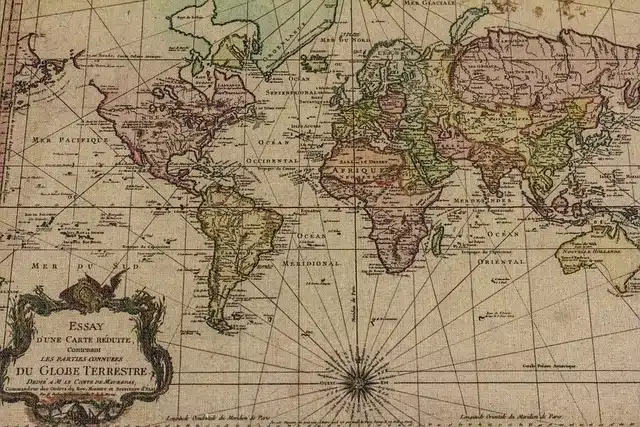
A terrestrial planisphere represents the sphere of the Earth in a plane.
The concept of planisphere is used to describe and identify a chart where the celestial sphere or the Earth is represented on a plane . It is a useful instrument for teaching and science.
For example: "The teacher asked us to bring a map for geography class" , "Grandpa said he would teach me how to locate the constellations on the map" , "Planispheres must be updated from time to time due to scientific discoveries" .
Earth planisphere
As noted when delving deeper into the matter, it is possible to distinguish between the terrestrial planisphere and the celestial planisphere . The terrestrial planisphere or world map is a cartographic representation based on the surface of our planet Earth . This map reproduces to scale on a plane the result of a geographical projection of the Earth's sphere.
The Earth map can focus on the political division of the world (thus showing the borders between nations) or on physical details (showing rivers, mountains and other geographical features). There are also more specific planispheres, such as geological or topographical ones.

Planisphere is often used synonymously with world map.
star chart
The celestial planisphere , for its part, is a star chart that is used to recognize the constellations and stars . It consists of a pair of discs that move on a common pivot.
What this planisphere does is show the projection of the celestial sphere on a flat surface, which implies a certain distortion. There are two main projection methods : the polar equidistant azimuthal projection (the sky is drawn centered on one of the celestial poles, with circles of equal declination that appear equidistant from each other and the poles) and the stereographic projection (the distances between the declination circles enlarges while the format of the constellations remains unchanged).
On the disk above you see a representation of the horizon, which graphs the divisible region of the sky at a given moment. In general, the horizon cannot be seen clearly, and this also happens with the stars. The main reason is that in a basic design, the disk is made starting from a special latitudinal point, restricting the celestial portion that will be seen on the planisphere. However, there are models that have different interchangeable parts, as well as others that contain more detail on the same disc.
Interpretation of the celestial planisphere
This characteristic is of vital importance when using a celestial map, since if it is chosen incorrectly, the study will return imprecise information. To locate a particular celestial body, it is necessary to verify its position at the time of measurement, given that they are in constant motion; The planisphere simply offers a Cartesian representation of a point in space, which must be compared with the updated information for the observation to yield correct results.
In certain cases it is possible to adjust the declination (that is, the distance measured in angles that exists between a star and the celestial equator, which is equivalent to the latitude of the Earth) with a piece independent of the discs, although it shares the same pivot. . For the rest of the planispheres, there is the possibility of printing said value on the disk in front, parallel to the straight line that connects the poles. On the margin, there is the representation of the right ascension and the chronological data necessary to locate oneself on a particular night.
To do this, it is necessary to rotate the disk until the time and day in question are aligned, taking into account the change that occurs in the summer. In this way, a representation of the stars that can be viewed at that specific moment is obtained.