 An image is a representation or appearance of something. The concept is usually used to refer to the reproduction of an element that arises when the light rays that come from it combine.
Satellite , on the other hand, is that linked to artificial satellites . This is the name given to space vehicles that are located in orbit around our planet or another star and that are equipped with machines to receive and transmit information.
From these definitions we can understand what a satellite image is. It is the visual representation of that information that is recorded by an artificial satellite .
These satellites have sensors that allow them to collect information that reflects the Earth's surface. Once they receive the data, they send it back to Earth , where it is processed.
On August 14, 1959, the satellite called Explorer 6 , belonging to the North American government, obtained the first satellite image of our planet. A few months later, on October 6, the Soviet Luna 3 satellite made the first capture of the Moon, while it was on a mission that aimed to take photographs of its hidden side .
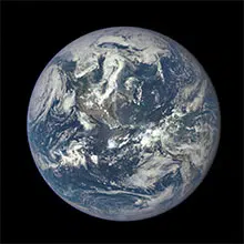
In this context it is necessary to talk about The Blue Marble , the name given to a satellite image of the Earth that the crew of the Apollo 17 ship captured on December 7, 1972. This photograph, which went down in history, was taken about 29,000 kilometers away from our planet. Its fame is so great that few images of the Earth have been used as many times as this one.
The official name that NASA gave to this satellite image is AS17-148-22727 and the Apollo 17 astronauts took it while they were traveling to the Moon. In it we can appreciate the space between Antarctica and the coast of the Mediterranean Sea. It is important to note that never before has Apollo been able to take a photograph of the south polar ice cap, although in the image the clouds cover it almost completely.
Another point to highlight about this satellite image is that it shows the coast of Africa almost in its entirety and with a good percentage of visibility. Also clearly present are Madagascar (the largest island on this continent), the Arabian Peninsula (of great relevance in the 1990 Gulf War , in addition to connecting Africa and Asia), and the southern region of the Asian continent at the top of the photography.
 On July 23, 1972, the United States launched the first satellite of a line called Landsat into orbit , which were built with the purpose of obtaining high-resolution satellite images of our planet. Since then they have launched several, and they are recognized by a serial number at the end of their name: until February 2013 there were eight, although by 2011 the first five had been out of service.
The orbit carried out by Landsats around our planet is a sun-synchronous circular orbit. They are 705 kilometers high, their inclination with respect to the equator is 98.2 degrees and their period is 99 minutes. Its passage from the Northern to the Southern hemisphere always takes place between 10:00 and 10:15 am.
Satellite images are used in multiple fields. Having this type of photographs of the Earth is very useful for cartography , for example. They are also used to study the climate , forecast atmospheric phenomena, and develop geographic information systems.
Meteorological satellites , to cite a specific case, orbit at an altitude of about 35,000 kilometers , taking images every one, two or three hours of various points on the planet . By moving at the same speed as the Earth 's rotation, each one allows you to always observe the same area.