 The Greek word geōdaisía , which can be translated as “division of the earth” , came to Spanish as geodesia . This is the name given to the scientific specialty focused on determining the magnitude and shape of the globe .
Geodesy is linked to the representation of the Earth's surface , whether partial or global, with its artificial structures and natural forms. From geodetic knowledge, it is possible to draw maps , for example.
Thanks to the theories , calculations and measurements of geodesy, the necessary references are obtained for the development of urban planning, cadastre, navigation and geographic information systems, among other issues.
In other words, the contributions of geodesy have a positive impact on the development of other geosciences . This concept is also known as Earth sciences , and is defined precisely as the set of disciplines of the natural sciences (which study the functioning of everything that surrounds us living beings), especially those that They focus on the observation of the shape, dynamics and evolution of our planet.
Another field that benefits from the results of geodesy is geomatics (also called geospatial technology or geomatics engineering ), the science that is responsible for the management of geographic data through the use of communication and information technologies. The information processing carried out by geomatics is made up of several stages, which are obtaining, modeling, processing, protection, consultation, analysis, representation and dissemination of geodesy, information systems geographic and remote sensing.
The origins of geodesy are in the Middle East . There, in Antiquity , a body of knowledge began to develop for the division of properties into plots. Roman surveyors took these formulas to calculate areas. In Greece , meanwhile, the first geodetic instrument was devised, known as a dioptra.
 Scientific advances allowed the creation of modern geodesy . With the launch of artificial satellites, the development of positioning and navigation systems was facilitated.
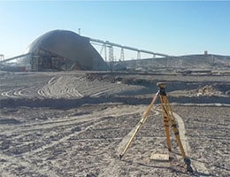
Geodesy, in short, has the purpose of determining the dimensions and shape of planet Earth , taking into account its gravity field and temporal changes. States generally have special organizations dedicated to establishing and updating geodetic reference frameworks, essential for the creation of cartography, the development of engineering works (such as the construction of dams or roads) and hydrocarbon research.
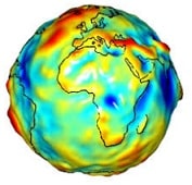
The gravity field is one of the fundamental topics of theoretical geodesy, and this covers both the observation and description of it and the changes it undergoes over time. Precisely, the gravity field suffers certain alterations due to the rotational movement of the Earth, as well as that of the other planets.
On the other hand, we talk about physical geodesics, where measurements of the Earth's surface are relevant, which are represented with points in triangulation networks. Thanks to the accuracy that geodesy provides to scientists, it is possible to project these points on a geometric surface for study from mathematics . For this purpose, a rotation or reference ellipsoid (a curved surface formed by three orthogonal elliptical sections) is usually used. There are some ellipsoids that were initially conceived with the goal of being used to study a single country, but over time they were applied to a continent or even the entire planet.